
The area around Chollerford (near Hexham) is much more well known for its Roman history than anything else; Hadrian’s wall with all its forts, milecastles and turrets, lies not far to the south after all. But it should not be forgotten that the little-known (and so-called) battle of Heavenfield (or Hefenfelth in the Old English vernacular) took place nearby in either 633/634 (some pesky confusion remains over the Venerable Bede’s dating references!).
This battle is commemorated by a wooden cross which stands on the northern side of the B6318, a little to the north of the Saxon town of Hexham. A bit further north, atop a low ridge that rises from that road, is a small chapel, dedicated to one of the protagonists, St Oswald. Blink and you’d miss it – as I have done more than once over the years.
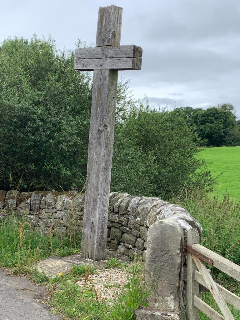
Author’s own photograph
The battle itself was one of a series of climactic events that took place during the course of a tumultuous 7th century; a century that saw the continued expansion of the Anglo-Saxon kingdoms (at the expense, mainly, of the native Romano-Britons) as well as attempts by a new-fangled middle eastern religion to gain a foothold amongst these Germanic pagans (we’re talking Christianity rather than Mithraism (though there are some interesting similarities…)). At that time, kings who died in their beds of natural causes were by far the exception.
The Battle
So, who was fighting and why?
In 632/33, King Oswald’s predecessor (and uncle by marriage), King Edwin had been killed in battle against an army from Gwynedd (under the Christian King Cadwallon ap Cadfan) in (a strange) alliance with the pagan king of Mercia, Penda. For the next year, Cadwallon then rampaged across Northumbria, looting and burning to his heart’s content, while the kingdom itself devolved into its two original, separate parts: Deira in the south and Bernicia to the north.
A cousin of Edwin’s – Osric – became king in Deira, but didn’t last long, being killed by Cadwallon while he attempted to besiege the King of Gwynedd. His opposite number in Bernicia, King Eanfrith also quickly came a cropper. But at least he learned that trying to negotiate a settlement with Cadwallon was a pointless exercise. (He and his leading thegns were assassinated.)
That left the stage set for Oswald (Eanfrith’s younger brother) to return from his 17-year exile in southwest Scotland (in an area known at the time as Dal Riata).

Author’s own photo of information board (presumably used for air-rifle target practice by the local hoodlums)
Arriving undetected near Hadrian’s Wall, Oswald made camp for the night. According to Bede, the king was visited by a vision of Saint Columba in his sleep who promised that victory would be his, despite his much smaller army (made up, probably, of Dal Riatan warriors with whom he had fought and grown close over the years, as well as whatever Bernician levies he could muster as he marched south).
As a result of this vision, Oswald then immediately erected a wooden cross and called the army to prayer. It is where the modern cross and chapel stand today that is believed to be the location of Oswald’s camp the night before the battle.
Note: there has been much confusion over the centuries about the location of the battle, with many historians believing that Heavenfield itself was the battleground, rather than just the site of Oswald’s camp. But Bede makes it very clear that Oswald marched out from the camp to meet Cadwallon in battle at a place called Denisesburn (or the brook of Denis).
The fact that no place called Denisesburn could be found merely added to the confusion and the tendency to relocate the battle to Heavenfield. But in the 1800s a 13th century charter was found which referred to a grant of land by the archbishop of York: “twenty acres of land from his waste in Ruleystal, between these boundaries, namely Deniseburn and Divelis…”.
This locality can therefore be pinned down to an area south of the River Tyne, some 7 or 8 miles from Heavenfield that lies at the confluence between two small rivers: Devil’s Water and Rowley Burn.
With this information, a more convincing picture begins to emerge of Oswald having camped the night before battle in full knowledge of where his foe was to be found (to the south). Having delivered his Saint Columba-inspired pep-talk to his army (no doubt designed to steel his men’s hearts against being outnumbered and up against the most successful and brutal warlord of his day), Oswald set out before dawn to catch Cadwallon by surprise within his fortified enclosure.
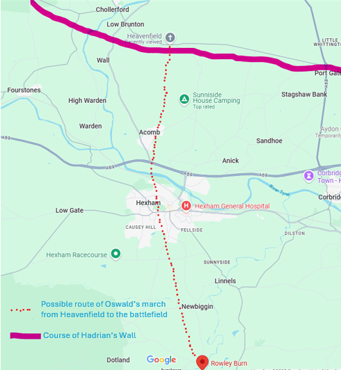
Author’s own map based on Google Maps extract
The route the army would have followed would most likely be due south from Heavenfield, past the village of Acomb (or Acum as readers of my Rebellion trilogy would recognise it) and down to the Tyne at a point where the river is wide, shallow and fordable. From there it would have been a steady climb up to Dotland which then overlooks the Rowley Burn. From the ridge, Oswald’s army would have been granted its first glimpse of Cadwallon’s camp through the early dawn mist, wherein the unsuspecting enemy was most likely still sleeping off the effects of a hard day’s pillaging and carousing.

Author’s own map based on Google Maps extract: X marks the spot.
It was here that Oswald and his men fell upon Cadwallon’s Welsh army and destroyed them where they slept, thereby securing the Kingdom of Northumbria and ushering in what is often referred to as the Golden Age of that region.
Note: There are many sources that discuss the Battle of Heavenfield, a good number of which get the location wrong. In creating this blog, however, I am hugely indebted to an article I found in issue 7 of the Hexham Historian from 1997 (niche, I’ll grant you): The Battle of Heavenfield by Tom Corfe.

Leave a comment